Borinquen Beach Aguadilla, Puerto Rico
Quick Facts
About Borinquen Beach
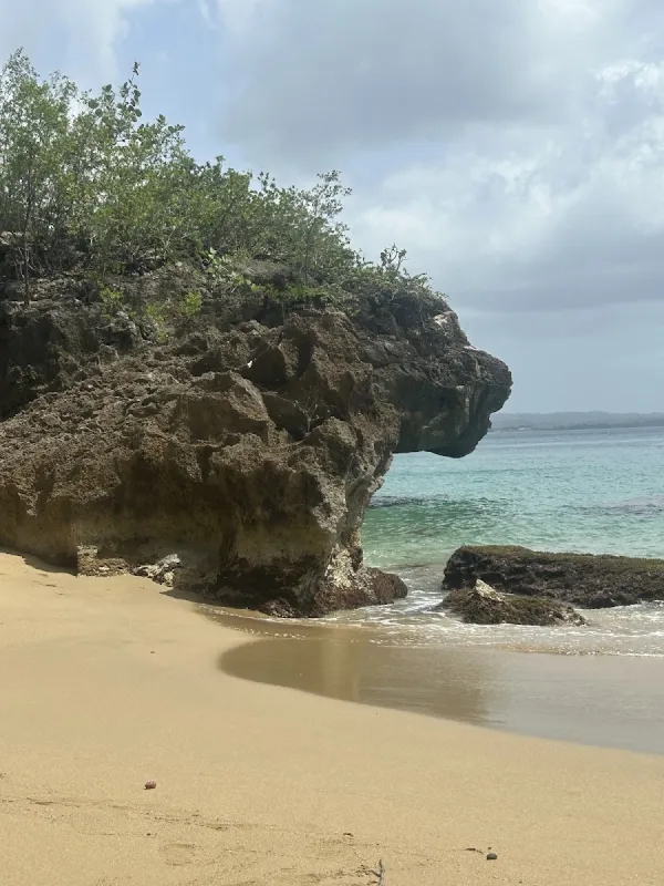
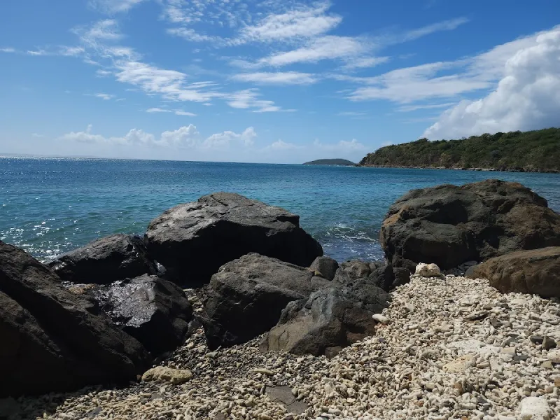
Borinquen Beach is a stunning stretch of white sand beach in Aguadilla, perfect for picnics, photography, and exploring dramatic rock formations. This scenic beach offers wide open spaces on both sides of the parking area, with historic lighthouse ruins nearby and beautiful views of turquoise waters against towering cliffs. It's ideal for beachcombers, photographers, and families seeking a peaceful retreat away from crowds.
Visitor Tips
- Visit during summer months at low tide for safest access to caves and rock formations, and arrive in late afternoon for spectacular sunset photography
- Perfect for picnicking under palm trees, beachcombing for sea glass and shells, photography at the lighthouse ruins, and exploring tide pools
- Exercise extreme caution when swimming due to strong Atlantic currents and undercurrents - not recommended for children, and no lifeguards on duty
- Free parking available at the beach entrance, accessed by driving through the golf course across from the airport runway
- Bring non-slip shoes or closed-toe sandals for exploring rocky areas and caves - flip flops are not recommended
- No restrooms, food services, or facilities available - bring everything you need including water, snacks, and sun protection
History & Background
Borinquen Beach lies along the northwestern coast of Aguadilla, a municipality with one of the most layered histories on the island. The beach's name derives from Borinquén, the Taíno name for Puerto Rico itself, reflecting the deep indigenous connection to this land. The Taíno people inhabited this coast for centuries before Spanish colonization, and archaeological evidence throughout the Aguadilla area, including ceramic shards, stone tools, and remnants of batey (ceremonial ball courts), confirms their sustained presence.
Aguadilla was founded in 1775 by Luis de Córdova, though European settlement in the area predates the municipality's formal establishment. Spanish explorers first made contact with Taíno communities in this region as early as 1493 during Columbus's second voyage. The name Aguadilla reportedly comes from the Spanish practice of collecting fresh water from springs near the coast, "agua" meaning water, as ships provisioned before continuing their journeys.
The cliffs and rock formations that frame Borinquen Beach are part of a distinctive geological feature of northwestern Puerto Rico. These limestone formations, shaped by millennia of wave action and weathering, create dramatic backdrops of eroded sea stacks and arched rock walls. The geological processes visible here are directly related to the same karst topography that created the famous cave systems of the island's northern interior.
Near the beach stand the remnants of the Punta Borinquen lighthouse, originally constructed in 1889 during the final years of Spanish colonial rule. The lighthouse was severely damaged by the 1918 earthquake, a 7.1 magnitude event that struck the Mona Passage and generated a tsunami that devastated Aguadilla's coastline. During the twentieth century, the area was transformed by the establishment of Ramey Air Force Base in 1939, which operated as a Strategic Air Command installation during the Cold War. The base closed in 1973, and its infrastructure was converted into the Rafael Hernández Airport, residential communities, and public recreation areas. Today, Borinquen Beach serves as a gathering point for local families and photographers, retaining a quieter character compared to Aguadilla's more developed beaches.
Best Time to Visit
Borinquen Beach is best visited during the dry season from December through April, when rainfall is less frequent and skies tend to be clearer for photography. The rock formations and cliffs photograph especially well during the golden hour, the first hour after sunrise and the last hour before sunset, when warm light accentuates the textures and colors of the limestone.
- Summer months (May–September) bring warmer water temperatures and generally calmer seas on this stretch of the northwest coast, though afternoon thundershowers are common. Planning morning visits during summer is practical.
- Weekdays are noticeably less crowded than weekends, when local families from Aguadilla and nearby Isabela make day trips. A Tuesday or Wednesday morning visit during the school year is ideal for solitude.
- Hurricane season (June–November) requires monitoring weather forecasts, as this exposed northwest-facing coast receives heavy wave action from distant tropical systems even when no storm directly threatens Puerto Rico.
Getting There
From San Juan, take PR-22 west, which becomes PR-2 past Arecibo. Continue on PR-2 into Aguadilla, then follow signs for the former Ramey Base area or Rafael Hernández Airport. The drive from San Juan takes approximately two hours under normal conditions.
- Take PR-22 west from San Juan, which becomes PR-2 past Arecibo.
- Continue on PR-2 into Aguadilla, following signs for the former Ramey Base area or Rafael Hernández Airport.
- From the airport roundabout, head north on PR-107 toward the coast.
- Follow local signs to Punta Borinquen; the beach is accessible via a paved road that passes the Punta Borinquen Golf Club.
Traffic through the Hatillo and Camuy stretch of PR-2 can slow during weekday rush hours and on Friday afternoons when weekend travelers head west. A paved parking area near the beach accommodates roughly 30 to 40 vehicles, with overflow parking available along the roadside. There are no parking fees, and the lot sits close to the sand, so the walk from car to beach is short. If arriving via Rafael Hernández Airport, the beach is less than ten minutes from the terminal, making it one of the most accessible beaches for visitors flying into the west coast. A vehicle is essential for exploring this area.
What to Bring
Camera Equipment:
- A camera is the most important item for Borinquen Beach; the rock formations, cliffs, and lighthouse ruins offer some of the best coastal photography on the island.
- Wide-angle lens to capture the scale of the cliff faces.
- Telephoto lens useful for isolating details in the eroded rock patterns.
- Polarizing filter to help manage glare off the water for landscape shots.
Sun and Water Protection:
- Reef-safe sunscreen (SPF 50 or higher) is a must, as shade is limited along much of the beach. Reapply frequently.
- Hat with a chin strap is practical given the steady coastal winds.
- Water shoes or sturdy sandals with ankle straps are recommended for walking among the rock formations; limestone can be sharp and slippery with algae.
Food and Drink:
- Water and snacks – pack your own, as there are no food vendors directly at the beach. The nearest reliable food options are about a ten-minute drive away.
- Cooler with drinks and sandwiches allows you to spend a full morning or afternoon without needing to leave.
- Trash bag to carry out everything you bring in; this beach has no regular maintenance crew.
Nearby Attractions
Borinquen Beach is surrounded by interesting attractions within a short drive, offering diverse activities for a full day in the Aguadilla area.
- Punta Borinquen Golf Club, located along the access road to the beach, occupies the grounds of the former Ramey Air Force Base golf course. The 18-hole course offers ocean views from several holes with significantly lower green fees than resort courses elsewhere on the island.
- Crash Boat Beach (Playa Crashboat), about fifteen minutes south in Aguadilla, is one of Puerto Rico's most popular swimming and snorkeling beaches. The beach takes its name from the rescue boats once stationed there during the Ramey Air Force Base era. The concrete pier is a local landmark, and food kiosks along the beach serve fried snacks and cold drinks.
- Aguadilla's Parque de Colón downtown, roughly ten minutes from the beach, features a historic plaza with colonial-era architecture and several restaurants serving local cuisine. El Meson Sandwiches, a Puerto Rican fast-food chain that started in Aguadilla, has its original location nearby.
- The Aguadilla Ice Skating Arena, an unexpected attraction in tropical Puerto Rico, is one of the few Olympic-sized ice rinks in the Caribbean. It is located on the former base grounds, about five minutes from the beach.
- Survival Beach, accessible via a short hike along the cliffs north of Borinquen, offers a more secluded cove setting with dramatic cliff walls on three sides. The trail requires moderate fitness and appropriate footwear.
Local Tips
- Explore the lighthouse ruins early in the morning before other visitors arrive and before the midday sun makes the exposed walk uncomfortable. The structures are not maintained or staffed, so watch your footing around crumbling walls and uneven ground.
- Be cautious about sea conditions; the water may appear calm near shore, but rip currents develop along the rock formations, especially during incoming tides. Swimming is not the primary draw here, and there are no lifeguards. If you do enter the water, stay close to shore and avoid swimming alone.
- Use GPS navigation carefully – the former Ramey Base area can be confusing for first-time visitors because the road layout follows a military grid pattern. Use GPS with a specific destination point (Punta Borinquen Lighthouse or Punta Borinquen Beach) rather than a street address.
- Avoid feeding stray dogs, which are common in the base area and generally docile. They should not be approached or fed, as it encourages them to linger near beach visitors and their food.
- Pair with Crash Boat Beach for a full day – visit Borinquen in the morning for photography and exploration in cooler hours, then head to Crash Boat for afternoon swimming and snorkeling with food vendors available for lunch.
Visitor Photos
Sign in to addNo photos yet. Be the first to share!
Reviews
No reviews yet. Be the first to share your experience!
Conditions
1 month agoLive Updates
No recent crowd data
Amenities
Practical Info
Exercise extreme caution when swimming due to strong Atlantic currents and dangerous undercurrents, especially during winter months. There are no lifeguards on duty, so visitors swim at their own risk.